The Hurricane Polo 2026 threat is intensifying along Mexico’s Pacific region as the powerful storm moves toward the Baja California Peninsula.
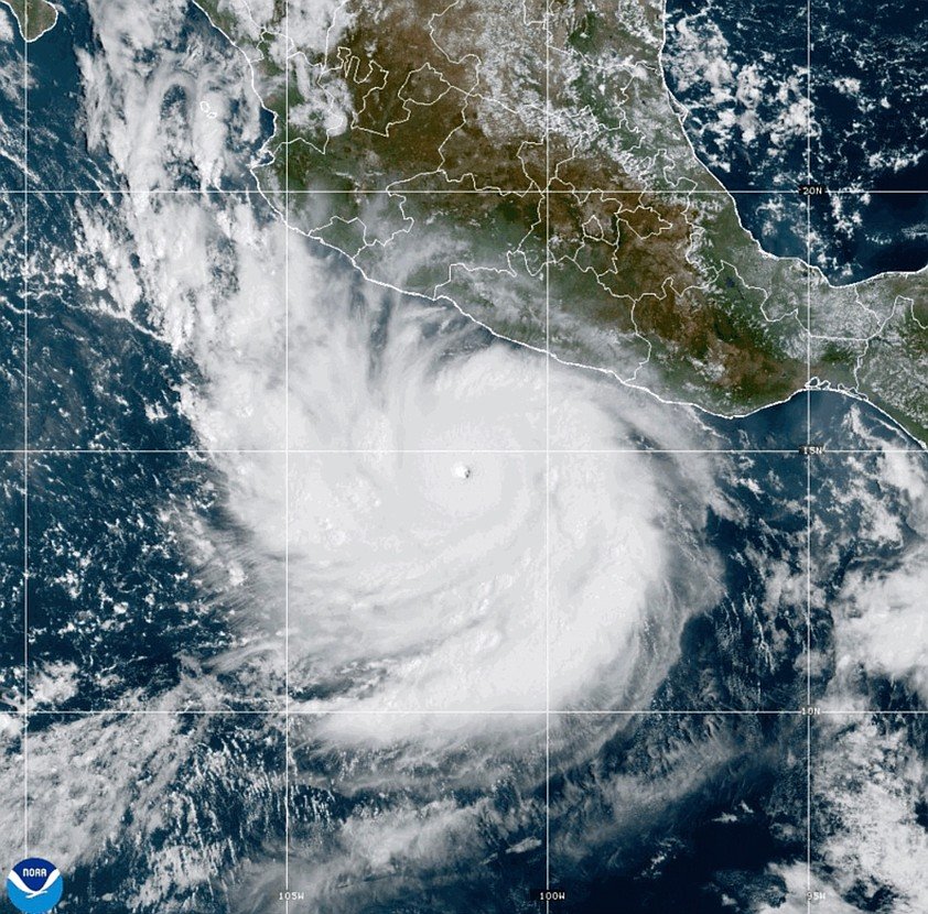
The National Hurricane Center reported on September 27 that Polo remained a Category 3 hurricane, with maximum sustained winds of about 125 mph (205 km/h). The storm was moving north at roughly 12 mph and was approaching Baja California Sur. Mexican authorities had issued hurricane and tropical-storm warnings for parts of the peninsula and mainland Mexico.
Polo has already undergone extraordinary changes during its development. Earlier in September, it briefly reached Category 5 strength with winds as high as 180 mph before weakening as it moved toward Mexico.
Although Polo has weakened from its peak, it remains capable of producing dangerous conditions.
Hurricane Polo Is Moving Toward Baja California
The latest National Hurricane Center advisory placed Polo about 260 miles west of Cabo San Lucas and approximately 175 miles southwest of Cabo San Lazaro.
The hurricane was moving north at around 12 mph.
Forecasters expected conditions to deteriorate as the storm approached the Baja California Peninsula.
The storm’s position and movement were particularly important because communities along the peninsula were preparing for strong winds, heavy rain, dangerous surf and possible flooding.
The National Hurricane Center urged residents to complete preparations to protect life and property.
Mexico Hurricane Warning Covers Multiple Areas
The Mexico hurricane warning reflects the seriousness of Polo’s approach.
As of the latest NHC advisory, hurricane warnings covered sections of Mexico, including parts of Baja California Sur and areas along the Gulf of California.
Tropical-storm warnings were also in effect in additional areas.
The exact warning zones can change as the hurricane moves, so residents and travelers should rely on the latest information from Mexican authorities and the National Hurricane Center rather than older forecasts.
Polo Was Once a Category 5 Hurricane
Polo’s recent history makes the storm particularly notable.
On September 25, the National Hurricane Center reported that Polo had reached Category 5 intensity, with maximum sustained winds of approximately 180 mph.
Earlier that week, Polo had rapidly intensified while moving across exceptionally warm Pacific waters.
The storm later weakened, but it remained a major hurricane for several days.
By September 27, NOAA Hurricane Hunter aircraft found Polo at Category 3 strength with winds of about 125 mph.
That dramatic change demonstrates why hurricane intensity can shift significantly within a relatively short period.
Why Category 3 Still Matters
A Category 3 hurricane is classified as a major hurricane.
Even after weakening from Category 5 intensity, Polo still has enough strength to cause serious damage.
Potential hazards include:
- Hurricane-force winds
- Dangerous storm conditions
- Heavy rainfall
- Flash flooding
- Mudslides
- Dangerous surf
- Rip currents
- Coastal flooding
- Road closures
- Power outages
The biggest risk is not necessarily limited to the location where the eye passes.
Large rain bands surrounding a hurricane can affect communities far from the center.
Heavy Rain Could Become a Bigger Problem
Rainfall may become one of the most significant hazards associated with Hurricane Polo 2026.
Mexico’s mountainous terrain can make heavy rainfall particularly dangerous.
When large amounts of rain fall within a short period, water can move rapidly through valleys and drainage systems.
That can trigger:
Heavy rain → rising rivers → flash flooding → landslides → road closures.
Areas that receive less direct wind damage can still face serious flooding.
Baja California Sur Faces the Immediate Threat
Baja California Sur is particularly important in the current forecast.
The peninsula contains popular tourist destinations, coastal communities and major transportation routes.
Cabo San Lucas and surrounding areas have been closely monitoring Polo as the storm moves north.
The U.S. Embassy in Mexico previously warned that Polo could produce dangerous ocean conditions, flooding, mudslides and road disruptions across parts of the Baja Peninsula.
For travelers, that means a storm does not have to make a direct hit on a major resort area to cause disruption.
Flights, roads, beaches and marine activities can all be affected.
Dangerous Ocean Conditions Are Another Threat
Hurricanes can create dangerous conditions at sea even when their centers remain offshore.
Large waves and powerful currents can extend well beyond the hurricane’s eye.
Authorities have warned about dangerous surf and rip currents associated with Polo.
That creates risks for swimmers, surfers, boat operators and people visiting beaches.
The safest approach during an active hurricane warning is to follow local restrictions and stay away from dangerous coastal waters.
Roads Could Become Difficult to Use
Heavy rain and flooding can quickly disrupt transportation.
Roads crossing low-lying areas may become flooded.
Mountain roads can also become vulnerable to mudslides and falling rocks.
If major routes are closed, emergency services may have difficulty reaching isolated communities.
Travelers should therefore monitor road conditions and official warnings before moving through areas affected by Polo.
Power Outages Could Follow
Strong winds and flooding can damage electrical infrastructure.
Trees and debris can fall onto power lines, while flooding can affect substations and other infrastructure.
Even temporary outages can become serious when they affect hospitals, communications systems, water services or emergency operations.
Residents in the storm’s path are generally advised to prepare for the possibility of losing electricity.
Why Polo Became So Strong
One of the most remarkable aspects of Polo’s development was its rapid intensification.
The storm strengthened dramatically over very warm Pacific waters.
Earlier forecasts noted unusually favorable atmospheric conditions for rapid strengthening, including warm ocean temperatures and relatively low wind shear.
Polo eventually reached Category 5 strength before weakening.
This rapid transformation attracted significant attention from hurricane forecasters because tropical systems can sometimes strengthen much faster than communities have time to prepare.
Polo’s Forecast Has Changed Before
Another important lesson from Polo is that hurricane forecasts can change.
Earlier forecasts expected the storm to approach Mexico while remaining offshore.
Later forecasts increasingly focused on the Baja California Peninsula as Polo’s track shifted.
The National Hurricane Center’s September 26 forecast indicated that Polo was expected to approach the west coast of Baja California Sur, cross the peninsula and then move toward northwestern mainland Mexico.
That is why residents should pay attention to updated forecasts rather than relying on a single projected path.
The Storm Is Not the Same as Its Peak Intensity
It is important to separate Polo’s historical peak from its current strength.
Polo previously reached Category 5 intensity.
However, the latest available NHC advisory described it as a Category 3 hurricane.
That means headlines referring to Polo’s earlier Category 5 strength should not be interpreted as its current intensity.
The current threat comes from the storm’s remaining hurricane-force winds, rainfall, ocean conditions and its approach toward Mexico.
What Residents Should Do
People in areas covered by hurricane or tropical-storm warnings should follow instructions from Mexican authorities.
Important preparations include:
- Secure loose outdoor objects.
- Stay away from beaches and dangerous surf.
- Avoid flooded roads.
- Keep emergency supplies available.
- Charge phones and backup batteries.
- Monitor official weather updates.
- Know evacuation routes.
- Avoid driving through moving floodwater.
- Follow evacuation orders if issued.
The most important information can change quickly as the storm approaches.
What Travelers Should Know
Tourists traveling through Baja California Sur and nearby regions should check official weather and transportation updates.
Flights can be delayed or canceled.
Roads can become dangerous.
Beach activities may be suspended.
Hotels and resorts may also change operating procedures during severe weather.
Travelers should avoid assuming that conditions will remain normal simply because the hurricane’s center is not directly over their location.
Could Polo Strengthen Again?
Hurricane intensity can fluctuate.
Polo weakened substantially from its Category 5 peak, but the National Hurricane Center continued to classify it as a major hurricane on September 27.
Forecast models can change as environmental conditions evolve.
For that reason, it is more useful to monitor the storm’s official intensity and forecast track than to assume that weakening will continue at a fixed rate.
Why This Hurricane Matters Beyond Mexico
Polo is important not only because of its immediate threat to Mexico.
The storm demonstrates how quickly tropical systems can develop into major hurricanes and how difficult it can be to predict their exact impacts several days in advance.
It also highlights the difference between a storm’s maximum intensity and its actual effects on land.
A hurricane can weaken before landfall and still produce dangerous flooding, destructive winds and hazardous coastal conditions.
The Next 24 to 48 Hours Matter
The next stage of Hurricane Polo 2026 will be closely watched.
As the storm moves toward Baja California, forecasters will monitor its intensity, movement and interaction with the surrounding atmosphere.
Communities under warnings need to complete preparations before conditions deteriorate.
The most important questions are whether Polo maintains hurricane strength as it approaches land, how much rainfall reaches affected areas and where the strongest winds and flooding occur.
Conclusion
Hurricane Polo 2026 remains a serious threat to Mexico despite weakening from its extraordinary Category 5 peak.
The latest National Hurricane Center advisory classified Polo as a Category 3 hurricane, with maximum sustained winds near 125 mph as it moved north toward the Baja California Peninsula.
A Mexico hurricane warning has been issued for areas expected to experience dangerous conditions, while additional tropical-storm warnings cover other locations.
The biggest concerns include hurricane-force winds, heavy rainfall, flash flooding, mudslides and dangerous ocean conditions.
Polo’s rapid intensification earlier in its life cycle also shows why residents cannot rely on early forecasts alone.
The storm has changed significantly in strength and track over the past several days.
For people in Baja California Sur and other areas covered by official warnings, the priority now is preparation, caution and following updated instructions from authorities.
The hurricane’s exact impacts will depend on its final track and intensity as it approaches Mexico.
Frequently Asked Questions
What is Hurricane Polo 2026?
Hurricane Polo 2026 is a powerful eastern Pacific hurricane that has moved toward Mexico after reaching Category 5 intensity earlier in September. The latest NHC advisory classified Polo as a Category 3 hurricane.
Is there a Mexico hurricane warning?
Yes. Mexican authorities have issued hurricane and tropical storm warnings for areas affected by Polo’s projected path. Warning areas can change as the storm moves.
What category is Hurricane Polo now?
The latest available National Hurricane Center advisory on September 27 classified Polo as a Category 3 hurricane, with maximum sustained winds of about 125 mph.
Did Hurricane Polo reach Category 5?
Yes. Polo reached Category 5 intensity earlier in September, with maximum sustained winds reported as high as 180 mph before weakening.
Which parts of Mexico are threatened?
Baja California Sur is facing the most immediate threat as Polo approaches the peninsula. Other parts of Mexico can also experience rain, flooding, dangerous surf and tropical storm conditions depending on the storm’s final track.
What are the biggest dangers from Polo?
The major threats include strong winds, heavy rain, flash flooding, mudslides, dangerous surf and rip currents.
Should tourists leave affected areas?
Travelers should follow instructions from Mexican authorities and their accommodation providers. Anyone in an evacuation zone or under an official evacuation order should follow that order immediately.